Saturday, April 30, 2011

Tornado tuscaloosa, Albama

Tornado path

Deadly tornadoes raked across Alabama on April 27, 2011, killing as many as 210 people as of April 29. The hardest-hit community was Tuscaloosa. The top image, acquired on April 28 by the Moderate Resolution Imaging Spectroradiometer (MODIS) on NASA’s Aqua satellite, shows three tornado tracks through and around the city. The lower image, from April 12, shows the area before the storm.

The tracks are pale brown trails where green trees and plants have been uprooted, leaving disturbed ground. Though faint, the center track runs from southwest of Tuscaloosa, through the gray city, and extends northeast towards Birmingham. Two other tracks run parallel to the center track. The northernmost track lies in an area where the National Weather Service reported a tornado, but no tornado was reported in the vicinity of the more visible southern track. In the southern region, strong winds were reported.

The tornadoes were part of a larger weather pattern that produced more than 150 tornadoes across six states, according to the National Weather Service. The death toll reached 300 on April 29, making the outbreak the deadliest in the United States since 1974.

Thursday, April 28, 2011

Low over bay of bengal

pHOTO FROM bbc


Low may form over bay of bangal  but no effect to indian it may go to myanmarg .

The Maximum Temperatures over Saurashtra and Gujarat were high on last Saturday and Sunday at most places of Saurashtra, Gujarat & Kutch  the winds have now started to blow mainly from the Westward direction and the Maximum Temperatures have dropped by a Degree or two in many places except Central Gujarat where the Maximum Temperatures have remained high

Tuesday, April 26, 2011

St. Louis tornado rated an EF-4


A violent EF-4 tornado ripped through St. Louis near 8pm local time Friday night, carving a 22-mile path of destruction up to 0.4 miles wide, and severely damaging Lambert International Airport. The airport, the world's 30th busiest, was closed much of the weekend, but has now re-opened. The tornado, rated an EF-2 when it hit the airport, ripped off the roof from Concourse C, blew out more than half of the windows in the main terminal, and moved an aircraft that was parked at a gate twenty feet. The tornado also passed over a residential area just west of the airport in the community of Bridgton, causing severe EF-4 damage, according to the National Weather Service office in St. Louis. This was the first violent EF-4 tornado of the year.


Before and after damage photo of Beaverton Drive in Bridgeton, Missouri, after the April 22, 2011 tornado. This damage was rated EF3. Image credit: National Weather Service office in St. Louis

Photo album

Golden Prairie under Troubled Sky
 Fantastic light near sunset on Laramie's prairies today...Sunday January 30, 2011 Laramie, WY


Piteraq 2

 Piteraq in Tasiilaq East Greenland....Wednesday April 20, 2011 Tasiilaq , Greenland

Severe Thunderstorms
 Lightning strike during severe storms rolling through the DFW area.Sunday April 24, 2011 Richardson, TX

Touch Down
 The  great afternoon of clouds building and sweeping across the mountains. Can you see the jet, at the top of the screen?             Thursday April 21, 2011 Kamloops , Canada

The Signature
The sunrise is God's greeting - the sunset, His signature~ and this Resurrection Sunday was beautifully signed by the artist Himself. I hope each of you had a lovely and blessed Easter.
                                       Sunday April 24, 2011 Anna Maria Island, FL,

 Hail After 30 Seconds!

                                        Sunday April 24, 2011 Brownwood, TX


4 Aeasons in a Day
  2 inches of snow .    Thursday April 21, 2011 Fall River Mills, CA

Signs of Spring

 Storm clouds gather in over the mountains.Tuesday April 19, 2011 Kamloops , Canada


Light and Shadow Day
                                        Love the April skies.   hursday April 21, 2011 Greenview


Lenticular Cloud

 Thursday April 21, 2011 Ridgecrest, CA

Buttes Sunset
  Clouds lighted by the setting sun on a stroll up ...Tuesday April 19, 2011 Laramie, WY

Flying Buttresses

with soaring spires, snow filled couloirs and an airbrushed mares tail sky, to adorn magnificent High Sierra architecture. Tuesday April 19, 2011 onion valley, Independence, CA


West rajasthan reached  +42 Now good condition , tempraure rise

Friday, April 22, 2011

South remain rainy

bangalore rain. Now it heavier and steady" (4:46pm)

       The Maximum Temperatures over Gujarat will trend upwards by tomorrow. The region between Ahmedabad and Godhra are expected to be some of the hot spots in Gujarat where the Maximum Temperature will go upto 42 to 43 Degrees C. by Saturday. Maximum Temperature at Rajkot is expected to cross 41 by Saturday.

      There is an upper air cyclonic circulation lying over Southeast Arabian Sea extending upto Mid-Tropospheric levels. Under the influence of this UAC, Kerala, Karnataka and Tamilnadu and Coastal Andhra Pradesh will receive medium rainfall on 22nd, 23rd and 24th April with heavy rainfall of upto 10 Cms. in isolated places of Kerala and Karnataka.

Thursday, April 21, 2011

no comment

Still raining in india , -ve point continue for SW Monsoon.

Wednesday, April 20, 2011

Sea suface temprature


Gujarat would start heating up immiedietly. Ahmedabad and Baroda can expect to touch 44c from friday, I expect some hot spots, maybe Gujarat , to become the first  in India to touch 45c.


Tuesday, April 19, 2011

Historic 3-day tornado outbreak kills at least 40

In a stunning display of violence, close to 200 tornadoes rampaged across the Midwestern and Southeast U.S. April 14 - 16 in one of the largest tornado outbreaks in history. At least 40 people died in the tornadoes, making it the deadliest tornado outbreak since the Super Tuesday tornado outbreak of February 5 - 6, 2008, which killed 57 people. Severe thunderstorms and flash floods killed at least seven more people in this April's severe weather outbreak. Hardest hit was Bertie Country in northeast North Carolina, where an EF-3 tornado carved a path of destruction 18.8 miles long and 1/2 - 3/4 miles wide, killing 11 people in the town of Colerain. It was the deadliest single tornado in the United States since May 10, 2008 in Picher, Oklahoma and Neosho, Missouri, which killed 21. Also hard-hit Saturday was the Raleigh area, where a 3/10 mile-wide tornado carved a 63-mile long path of destruction through downtown. Damage was rated EF-2 in downtown Raleigh, but was EF-3 along other portions of its path, and the tornado killed five people. The 23 tornado deaths in North Carolina made Saturday's outbreak the deadliest day for tornadoes in the state since 1984, when the infamous March 28 tornado outbreak killed 57 people and injured 1248. The 1984 outbreak had more violent tornadoes--seven F4 twisters in all. None of the tornadoes in this year's outbreak have been rated above EF-3, as of yet.


Figure 1. Viewer-uploaded photo sent to WRAL of damage in Fayetteville, NC on Saturday.

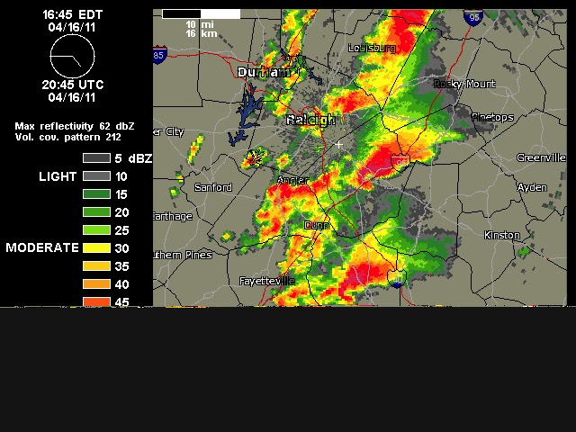
Figure 2. Radar reflectivity image of North Carolina on Saturday during the height of the tornado outbreak, showing four simultaneous hook echoes of tornadoes. The storm at the top of the image is the EF-3 tornado that ripped through Raleigh, killing five people.

One of the largest tornado outbreaks in history

NOAA's Storm Prediction Center logged 120 preliminary tornado reports on Saturday, 120 on Friday, and 27 on Thursday, bringing the 3-day total to 267 twisters. In past years, these preliminary tornado reports typically were an over-count of the actual confirmed tornado totals by about 15%. However, this year the Storm Prediction Center stopped trying to filter out preliminary reports they thought were from the same tornado, so the over-count may be higher. Even so, the 3-day April 14 - 16 2011 tornado outbreak will likely will end up with close to 200 confirmed tornadoes, making it the largest tornado outbreak since the 235 tornadoes recorded in the May 22 - 31, 2008 outbreak. According to a list of tornado outbreaks maintained by Wikipedia, only two other tornado outbreaks have had as many as 150 twisters--the May 2004 outbreak (385), and the May 2003 outbreak (401). An average April typically has 150 - 160 tornadoes across the entire U.S.

Another significant severe weather outbreak coming on Tuesday


NOAA's Storm Prediction Center is predicting another major severe weather outbreak for the Midwest on Tuesday, when a strong cold front is expected to sweep across the Mississippi and Ohio River Valleys. A "moderate" risk of severe weather is expected across much of Missouri, Illinois, and Indiana. The weather conditions are not expected to be as conducive for severe weather as was the case Saturday, when SPC placed much of North Carolina in their "high risk" area for severe weather, the only "high risk" forecast they've issued this year.


Figure 4. Severe weather risk for Tuesday.

Wikipedia has a nice summary of the April 14 - 16 tornado outbreak.

Tornado - Pine Apple,AL (EarlBcom)

Tornado just south of Pine Apple, AL on around 5:40pm. This storm was a part of the Alabama tornado outbreak on April 15, 2011. earlb.com VIDEO - See video of tornado at earlb.com


Saturday, April 16, 2011

Photo Album


 Komna - Julian Alps, Slovenia

                         Sunday April 3, 2011 Kobarid , Slovenia


   Thunderstorm over Maputo

              Uploaded by: Loirinha1 Sunday April 3, 2011 Maputo,

Clouds N' Spring

Uploaded by: got2dogs Friday April 8, 2011 Fall River Mills, CA

 Alpine Grandeur
 Uploaded by: tahomus Wednesday April 6, 2011 north oak creek canyon, Independence

                                            Hail Stones


Uploaded by: ThunderBev Sunday April 10, 2011 Thunder Bay ,

                                        Sun set


 Uploaded by: minnesotamom Friday April 8, 2011 Meadowlands, MN

Totally untouched...this is exactly how it came out of the camera.


 Wow
 Uploaded by: Altred Tuesday April 5, 2011 Senja , Norway


 Lanikai Beach Sunrise

Uploaded by: bob1978 Tuesday April 5, 2011 Kailua, HI

HDR sunrise over Lanikai Beach.

 Cascade Mountain Range 2


Uploaded by: MilesacresFriday April 8, 2011 Marblemount, WA


Sun Set


Uploaded by: minnesotamom Friday April 8, 2011 Meadowlands, MN


Totally untouched...this is exactly how it came out of the camera

Unstable weather over large area of india


With a fresh western disturbance expected to cross into the western Himalayas and the adjoining plains of northwest India, regional weather is expected to remain unstable during the weekend and into the next.

The rumble would also be heard in distant east and northeast India as well as the south, as offspring troughs and associated circulations dig in over these regions.

WEATHER WARNING

An India Meteorological Department (IMD) update on Thursday evening said that the fresh westerly would start affecting the western Himalayas and adjoining plains from Friday onwards.

An upper air cyclonic circulation in the lower levels over Bihar and neighbourhood persisted from overnight as did a counterpart circulation over Nagaland.

A weather-making trough lay extended from southwest Madhya Pradesh to coastal Kerala across Maharashtra and Karnataka.

A weather warning valid until Saturday said that isolated thunder squalls would occur over Bihar, Jharkhand, Chhattisgarh, Orissa, West Bengal and Sikkim.

Global weather models also indicated that the unstable weather (as distinct from stable or clear) would spill over into the next week.

WIDESPREAD RAIN

The 24 hours ending on Thursday morning said that fairly widespread rain or snowfall was reported from Himachal Pradesh while it was scattered over Uttarakhand and isolated over Jammu and Kashmir.

Fairly widespread rainfall also broke out over Assam, Meghalaya and Kerala; scattered over Uttar Pradesh, Karnataka, Lakshadweep, Orissa, sub-Himalayan West Bengal, Sikkim and Chhattisgarh.

It was isolated over Madhya Pradesh, Maharashtra, Andhra Pradesh, Jharkhand, Bihar, Gangetic West Bengal, Tamil Nadu and Andaman and Nicobar Island.

Satellite pictures on Thursday afternoon revealed the presence of convective (rain-bearing) clouds over parts of sub-Himalayan West Bengal, Sikkim, the Northeastern States, south interior Karnataka and southeast Arabian Sea.

MORE RAIN SEEN

A short-term IMD outlook valid until Sunday said that widespread to fairly widespread rain, thunderstorms and dust storms would be unleashed over most of these areas in varying intensities.

An extended forecast valid until Tuesday said that scattered rain or snow would occur over the western Himalayan region.

Friday, April 15, 2011

Cloud shadows


cloud shadows can occur when the sun is higher in the sky. From aloft, in an aircraft, a person can look out the window and see large cloud shadows on the ground. Most everyone has experienced a cloud shadow. On any sunny day, a cloud will sometimes cross over the sun and the sun will disappear temporarily. Here is a great video of cloud shadows moving over Utah.


Few chance over saurastra to day.....

Thursday, April 14, 2011

On the Earth As It Heaven


                                  09 April ,Sunset, Malibu, CA


Wednesday, April 13, 2011

Global sea temprature


Global sea surface temprature

A heat wave will start over Central and E.central India from 17-Apr .. and a circulation will be over central India at that time.

 Some scattered heavy T.showers forecast for Bengal and Bangladesh on 15,16,17-Apr

Monday, April 11, 2011

Test of rain.....


Heavy cloud activity over Pakistan, into Rajasthan and entire N-W India is cloudy with scattered rain around ..

Saturday, April 9, 2011

To day's photo

wIND ADVISORY ,,,2 APRIL

Good thunder over chatisgarh,vidarbh,zarkhand &karnataka


Heavy thunder activity over S-E Madyapradesh, N,S Chatisgarh, Jharkand, Bihar, S-W,central Karnataka

Nagpur,Today around 16.00. Hailstorm video  ... The video is available here http://fb.me/TNIf2QFO

Heavy thunder showers forecast for E. central, N-E India till 15-Apr and beyond ... will peak around 13,14,15-Apr.

Thursday, April 7, 2011

Tuesday, April 5, 2011