Thursday, December 29, 2011
Thane than thane
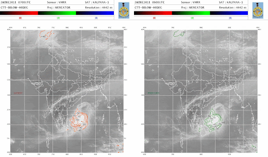
180km East of Pondicherry!
Position, 3:30pm:: 11:48:01 N and 81:34:20 E
Winds :: up to 125 km/hr
Pressure :: 982mb
Showing NO sign of weakening yet, but expected to weaken from midnight!
Continue to track west towards Pondicherry, now located around 190km East of Pondicherry.
Chennai will have to bear up to 80% of the Cyclones fury !
Extreme heavy rains with Wind gusts up to 100 km/hr will start along Chennai to Pondicherry coast from 6pm.
Wednesday, December 28, 2011
Friday, December 16, 2011
Wednesday, November 30, 2011
As per the latest NRl/JTWC report, AS-4 has weakened in the last 6 hrs. , this system is now expected to fizzle out over the A.Sea in the next 36 hrs. The centre is currently at 17N and 64E, roughly 900 kms W/SW of Mumbai.Cloud bands to the NW of the centre persist, with winds at 25 knts in that region.
Monday, November 28, 2011
300 post .....
AS-4 as on 2.30pm Monday: 14.4N and 68.7E...moved Due West since 11.30 am Monday
AS-4, IMD has declared it as a deep depression now, is currently located at 14.3N and 69E, thus moving NW again, and steadily. It is due west of Mangalore on Monday morning.
This system has strengthened, and a deep convection is seen in the cloud mass N/NW of the centre. The thick mass is spread from 13.00N to 19.00N and 64.00E to 71.00E. In fact, the convection effect has towered the cloud tops to more than 18-20 kms in height, with the lowest minimum cloud top tempertaure touching -85c !
Well, it is expected to strengthen more, till Tuesday, when it would have reached its peak.After that, it will weaken considerably, and may not cross coast as a system at all.
Reason: The SST is 29c at the centre now, and is decreasing northwards.The ocean heat content is 80-90 KJ/cm2 as on the system's location now, but becomes less than 40 KJ/cm2 towards the North Arabian Sea.The anti cyclone on the East coast of India is pushing westwards.
Saurashtra/South Gujarat coast and North Konkan will be cloudy and have light rains on Monday.
Indications show the clouding moving towards the Sindh coast from Tuesday.
Saturday, November 26, 2011
Flying cloud over gujarat from tomorrow.....
The system is at 8.2N and 76E, about 200 kms due South of Cochin. Thus having moved N, system, now a depression, though I would put it at deep depression strength, with a core pressure at 996 mb and 35 knts winds. It is expected to storm into the Lakshdweep seas Saturday. Very heavy rains in the islands and Kerala this week end.
Friday, November 25, 2011
Tuesday, November 22, 2011
Wednesday, November 9, 2011
Monday, November 7, 2011
Saturday, November 5, 2011
Thursday, November 3, 2011
Oman rain
Muscat, Nov 2: Heavy rains lashed the region on Wednesday November 2, throwing normal life out of gear. Ruwi and other regions were badly affected.
Darsait and Wadi Kabir area experienced a different atmosphere this afternoon, when, at around 1 pm all of a sudden dark clouds gathered in the sky and heavy downpour started. Wadis arround Wadi Kabir, Ruwi, Mattrah and Darsait began overflowing.
There were huge traffic jams everywhere. Children had great difficulty in reaching home after school. Meteorological department has forecasted heavy rain on Wednesday night.
Sources said that six people lost their lives in the heavy rains in Rustaq and Batinah regions.
Pedestrians were seen wading through the flooded streets while traffic came to an almost standstill.
In Ruwi, Hamriya Roundabout reportedly collapsed, leading to more chaos. Cars and trucks too were washed away.
Police have instructed people to remain indoors.
Subscribe to:
Posts (Atom)


